Previous | Next
Jackson Hole Ski Map
Jackson Hole Ski Map Framed

Jackson Hole Ski Area

If you haven’t skied Jackson Hole, can you really say you’ve skied the west? Jackson Hole Mountain Resort, or “The Village” as locals fondly call it, is one of the definitive homes of big mountain skiing. Its iconic aerial tram serves 4,100 vertical feet of continuous skiing, from the summit of Rendezvous Mountain, all the way back down to the valley floor. Classic runs like Corbet’s Couloir dot the high alpine slopes near the summit, but give way to world-class groomers and great tree skiing on the lower mountain. And Niehues didn’t just capture Jackson Hole’s inbounds terrain when he painted this map. It also gives a great overview of the Rock Springs area, accessed to the south of the resort, as well as Grand Teton National Park which bounds the resort’s northern flank.

If you’ve ever taken a ride up the “big one”, looked down Corbet’s Couloir, or grabbed a waffle from the tram station, this trail map will stir up fond memories of skiing at Jackson Hole. James Niehues originally painted this map in 1993 and then revised and updated it in 2015 to reflect the mountain’s expansion, so it carries the weight of the area’s skiing and expansion. Jackson is the last of the old west, and this Jackson Hole ski map is like a portal to the world of simple living and big mountains.


Location: Teton Village, Wyoming, U.S.

Nearest city: Jackson - 12 miles (20 km)

Coordinates: 43.59°N 110.89°W

Vertical: continuous 4,139 ft (1,262 m)

Top elevation: 10,450 ft (3,185 m)

Base elevation: 6,311 ft (1,924 m)

Skiable area: 2,500 acres (10 km2) inbounds 3,000 acres (12 km2) backcountry

Runs: 116 , 10% easiest , 40% more difficult , 50% most difficult

Longest run: 4.5 miles (7.2 km)

Lift system: 1 tram - (100) 2 gondolas - (8) 11 chairlifts - 4 high-speed quads - 4 fixed-grip quads - 1 fixed-grip triple - 2 fixed-grip doubles 1 magic carpet 1 rope tow (halfpipe)

Lift capacity: 16,733 / hr

Terrain parks: 2

Snowfall: 459 inches (1,170 cm)

Snowmaking: 160 acres (0.65 km2)

Night skiing: none

Jackson Hole Ski Map

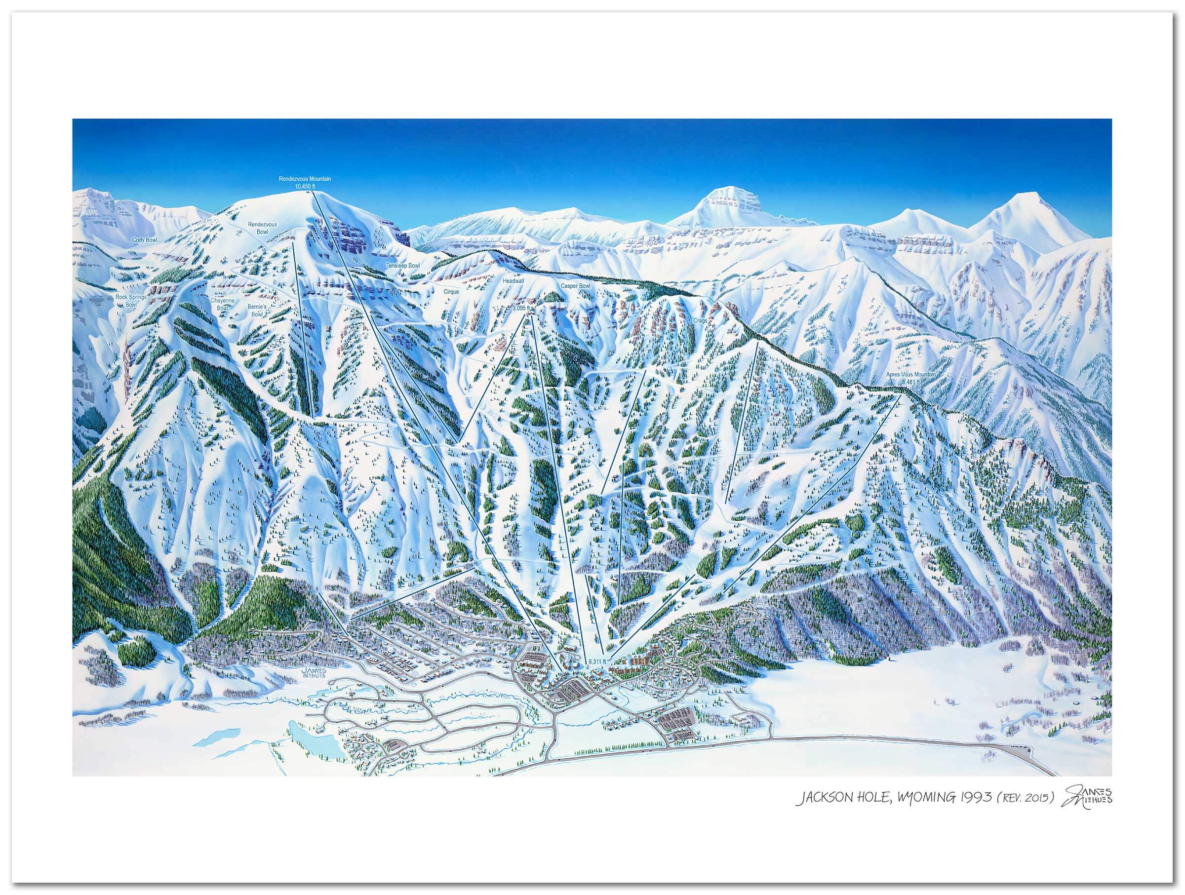
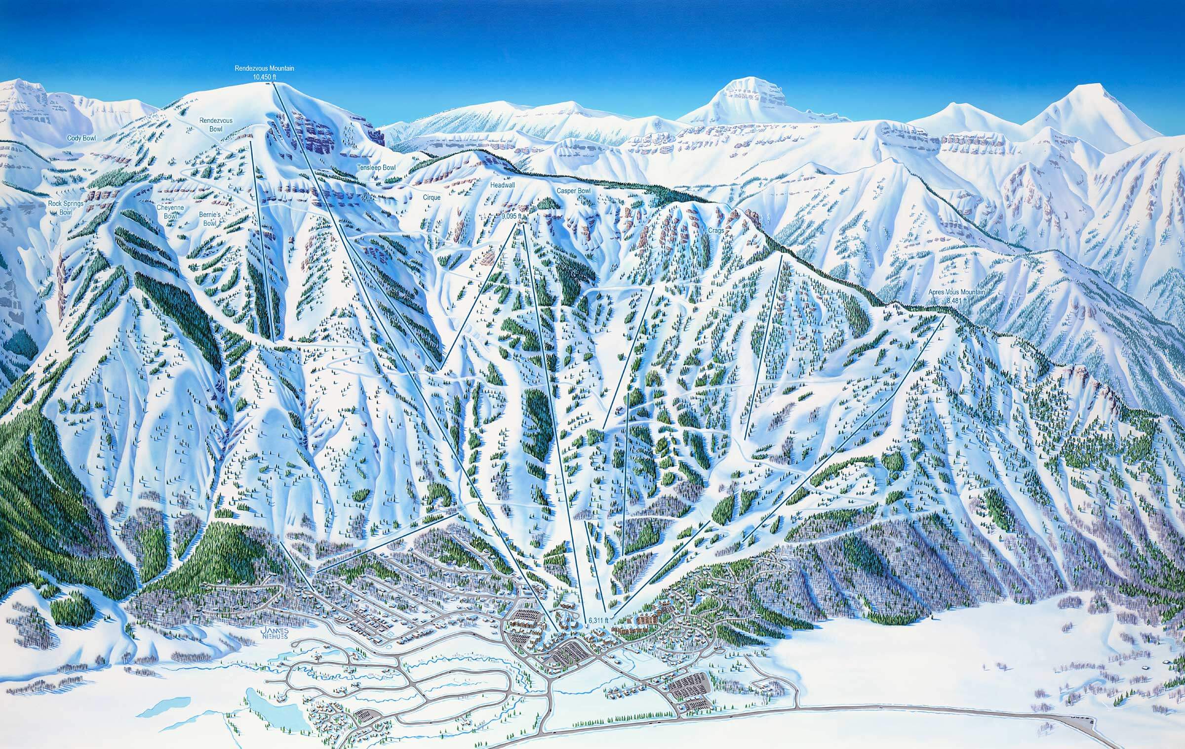
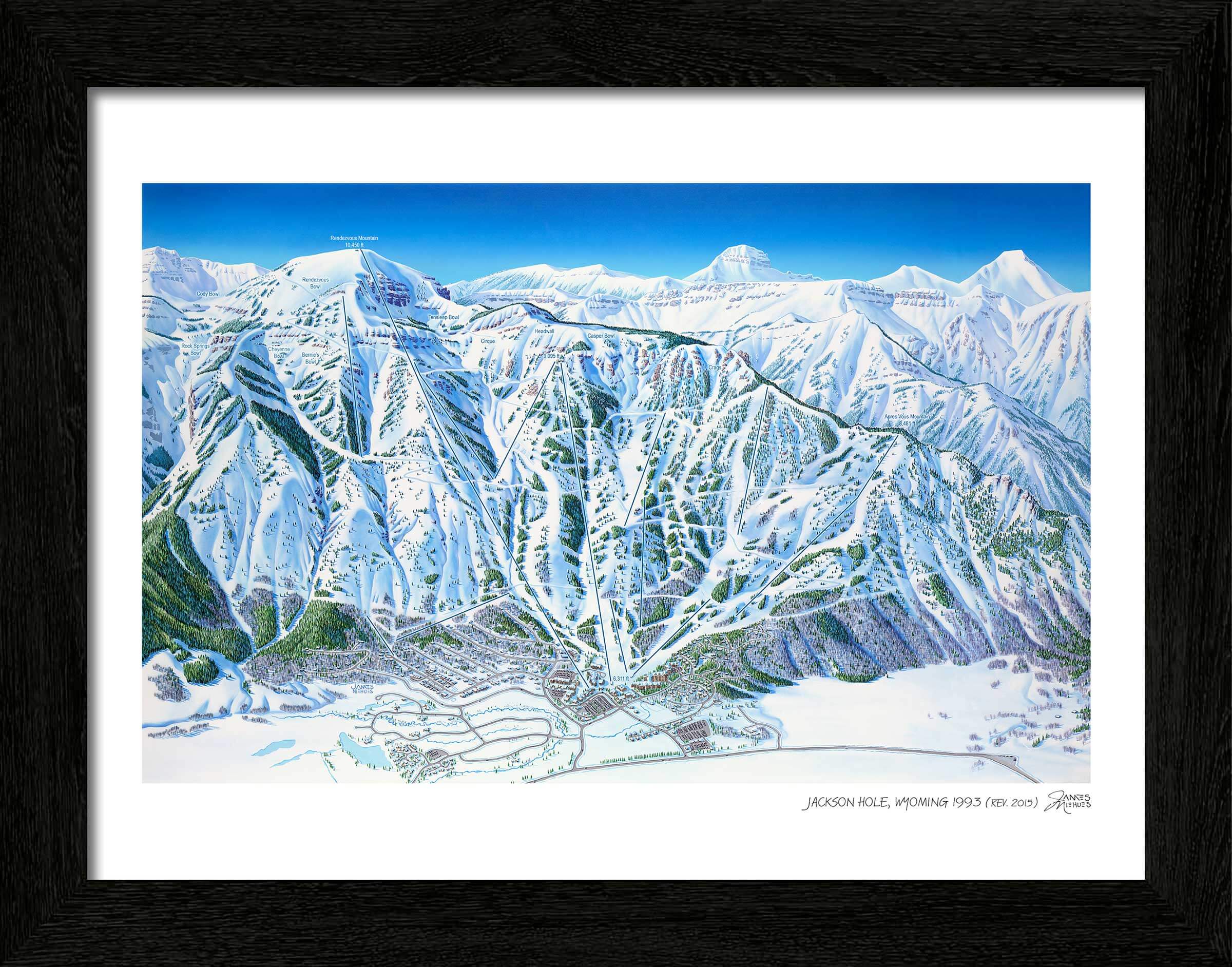
Jackson Hole Mountain Resort in Teton Village, Wyoming

Painted in 1993, revised in 2015

Our custom black wooden frames feature a deep, squared profile to showcase Niehues’ timeless work. Frame width ranges from ⅞ to 1 ⅝ inches, dependent upon on print size, and features a non-glare acrylic front plus foamcore backing.


Take the entire Book home with you today

The Man Behind The Maps Book

Jackson Hole Ski Area

If you haven’t skied Jackson Hole, can you really say you’ve skied the west? Jackson Hole Mountain Resort, or “The Village” as locals fondly call it, is one of the definitive homes of big mountain skiing. Its iconic aerial tram serves 4,100 vertical feet of continuous skiing, from the summit of Rendezvous Mountain, all the way back down to the valley floor. Classic runs like Corbet’s Couloir dot the high alpine slopes near the summit, but give way to world-class groomers and great tree skiing on the lower mountain. And Niehues didn’t just capture Jackson Hole’s inbounds terrain when he painted this map. It also gives a great overview of the Rock Springs area, accessed to the south of the resort, as well as Grand Teton National Park which bounds the resort’s northern flank.

If you’ve ever taken a ride up the “big one”, looked down Corbet’s Couloir, or grabbed a waffle from the tram station, this trail map will stir up fond memories of skiing at Jackson Hole. James Niehues originally painted this map in 1993 and then revised and updated it in 2015 to reflect the mountain’s expansion, so it carries the weight of the area’s skiing and expansion. Jackson is the last of the old west, and this Jackson Hole ski map is like a portal to the world of simple living and big mountains.


Location: Teton Village, Wyoming, U.S.

Nearest city: Jackson - 12 miles (20 km)

Coordinates: 43.59°N 110.89°W

Vertical: continuous 4,139 ft (1,262 m)

Top elevation: 10,450 ft (3,185 m)

Base elevation: 6,311 ft (1,924 m)

Skiable area: 2,500 acres (10 km2) inbounds 3,000 acres (12 km2) backcountry

Runs: 116 , 10% easiest , 40% more difficult , 50% most difficult

Longest run: 4.5 miles (7.2 km)

Lift system: 1 tram - (100) 2 gondolas - (8) 11 chairlifts - 4 high-speed quads - 4 fixed-grip quads - 1 fixed-grip triple - 2 fixed-grip doubles 1 magic carpet 1 rope tow (halfpipe)

Lift capacity: 16,733 / hr

Terrain parks: 2

Snowfall: 459 inches (1,170 cm)

Snowmaking: 160 acres (0.65 km2)

Night skiing: none

"The 'Rembrandt of snow' has published a hefty coffee table book with a collection of nearly all of his hand-painted maps."


Timeless art for your home

Hand-painted maps require the best reproduction process available. Each illustration starts with a high resolution digital scan. It is then printed on museum quality cotton paper using the latest HDR ink-jet technology.

Legendary Ski Artist James Niehues

If you are a skier or snowboarder, there is a good chance James Niehues has been your mountain guide. Throughout his 30 year career he has worked at the  smallest hills and the most expansive resorts in North America.  He has left his mark in South America, Australia, Asia and Europe too.   And even if you have never shared a bottomless powder day with him, he has always been close by.